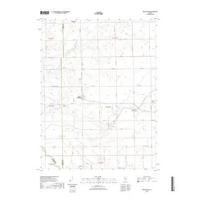
2018 Map of New Holland
USGS Topo · Published 2018About this map
New Holland serves as the central hub of this Central Illinois landscape, where the flat agricultural plains of Logan and Mason Counties are dissected by winding watercourses. The village layout is oriented along W Lincoln St and Logan St, surrounded by an expansive grid of county roads that define the region's farming heritage. Meandering through the southern half of the sheet, Sugar Creek and Salt Creek provide the primary relief to the otherwise level terrain, creating localized wetlands and wooded corridors. North of the village, Prairie Cr cuts through the northern townships near the settlement of Harness. Several historic burial grounds, including Stephen's Cem and Richmond Grove Cem, are scattered across the quadrangle, often situated near the drainage basins or atop subtle rises like Pool Hill. The presence of Martin Airport on the eastern edge reflects the modern intersection of aviation with this traditional rural environment.
Find a feature on this map
58 named features on this map. Tap any name to fly to it.
Don’t see what you’re looking for? This feature index may not catch every label — zoom into the map to look around manually.
Map Details
Editions of this 2018 New Holland Map
This is the sole edition of this map. No revisions or reprints were ever made.
Other maps of this area

1911 · Lincoln
USGS Topo · 1:62,500

1913 · Lincoln
USGS Topo · 1:62,500

1942 · Delavan
USGS Topo · 1:62,500

1948 · Mason City
USGS Topo · 1:62,500

1949 · Mason City
USGS Topo · 1:62,500

1951 · Minier
USGS Topo · 1:62,500

1958 · Peoria
USGS Topo · 1:250,000

1961 · Peoria
USGS Topo · 1:250,000

1963 · Peoria
USGS Topo · 1:250,000
1980 · Lincoln West
USGS Topo · 1:24,000