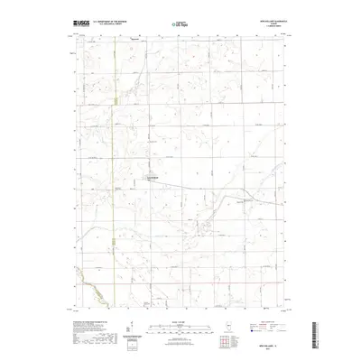
2021 Map of New Holland
USGS Topo · Published 2021About this map
New Holland serves as the primary hub of this agricultural landscape in Logan County, where a grid of rural roads connects scattered farmsteads and historic burial grounds. The terrain is defined by the winding paths of Sugar Creek and Prairie Cr, which carve through the prairie towards their confluence with Salt Creek at the southern boundary. This map reveals a high density of small family or community cemeteries, such as Stephens Cem and Richmond Grove Cem, which often represent the only remaining physical landmarks of early rural settlement patterns. Near the northeastern corner, the name Harness marks a distinct point in the landscape, while Pool Hill and its namesake Pool Hill Cem rise above the surrounding flats. The preservation of these sites alongside the modern road network allows for a precise study of how local land divisions and drainage patterns have persisted over generations.
Find a feature on this map
32 named features on this map. Tap any name to fly to it.
Don’t see what you’re looking for? This feature index may not catch every label — zoom into the map to look around manually.
Map Details
Editions of this 2021 New Holland Map
This is the sole edition of this map. No revisions or reprints were ever made.
Other maps of this area

1911 · Lincoln
USGS Topo · 1:62,500

1913 · Lincoln
USGS Topo · 1:62,500

1942 · Delavan
USGS Topo · 1:62,500

1948 · Mason City
USGS Topo · 1:62,500

1949 · Mason City
USGS Topo · 1:62,500

1951 · Minier
USGS Topo · 1:62,500

1958 · Peoria
USGS Topo · 1:250,000

1961 · Peoria
USGS Topo · 1:250,000

1963 · Peoria
USGS Topo · 1:250,000
1980 · Lincoln West
USGS Topo · 1:24,000