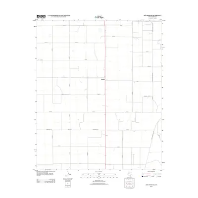
2012 Map of New Home SE
USGS Topo · Published 2012About this map
Wayside serves as the primary landmark in this section of Lynn County, located at the intersection of Fm-211 and the main highway. The landscape is defined by a rigorous grid of county roads, including north-south routes like Co Rd O and Sam Rd, reflecting the highly organized agricultural development typical of the Texas South Plains. This map captures a rural community structured around its transportation network, where even small-scale education centers like Dixie School on Ranch Road 1317 provide a localized sense of place. The intricate network of Farm-to-Market roads, such as Farm-To-Market Road 2192 and Farm-To-Market Road 400, illustrates the late-century infrastructure designed to connect isolated farmsteads with larger regional markets, preserving a specific 2012 snapshot of this Llano Estacado landscape.
Find a feature on this map
30 named features on this map. Tap any name to fly to it.
Don’t see what you’re looking for? This feature index may not catch every label — zoom into the map to look around manually.
Map Details
Editions of this 2012 New Home SE Map
This is the sole edition of this map. No revisions or reprints were ever made.
Other maps of this area

1954 · Lubbock
USGS Topo · 1:250,000

1957 · New Home
USGS Topo · 1:62,500

1965 · Slaton
USGS Topo · 1:24,000

1965 · Wilson
USGS Topo · 1:24,000

1969 · Tahoka
USGS Topo · 1:24,000

1969 · Double Lakes
USGS Topo · 1:24,000

1970 · New Lynn
USGS Topo · 1:24,000

1976 · New Home NW
USGS Topo · 1:24,000

1976 · New Home NE
USGS Topo · 1:24,000
1976 · New Home SE
USGS Topo · 1:24,000