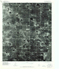
1976 Map of New Home SE
USGS Topo · Published 1978About this map
Wayside sits at the center of this 1976 orthophotoquad, which captures the rhythmic agricultural patterns of the Texas High Plains in Lynn County. Derived from high-altitude aerial photography, this document reveals the precise layout of large-scale farming plots and the rectangular grid of rural section roads that define this portion of the Llano Estacado. The imagery highlights the distinct contrast between tilled fields, pasture land, and the scattered playa lakes characteristic of the region. This specific perspective provides researchers with a clear record of land use and rural settlement at Wayside during a period of transition in West Texas agriculture, showing the exact footprint of farmsteads and field boundaries before later decades of consolidation.
Find a feature on this map
1 named feature on this map. Tap any name to fly to it.
Don’t see what you’re looking for? This feature index may not catch every label — zoom into the map to look around manually.
Map Details
Editions of this 1976 New Home SE Map
This is the sole edition of this map. No revisions or reprints were ever made.
Other maps of this area

1954 · Lubbock
USGS Topo · 1:250,000

1957 · New Home
USGS Topo · 1:62,500

1965 · Slaton
USGS Topo · 1:24,000

1965 · Wilson
USGS Topo · 1:24,000

1969 · Tahoka
USGS Topo · 1:24,000

1969 · Double Lakes
USGS Topo · 1:24,000

1970 · New Lynn
USGS Topo · 1:24,000

1976 · New Home NW
USGS Topo · 1:24,000

1976 · New Home NE
USGS Topo · 1:24,000
1976 · New Home SW
USGS Topo · 1:24,000