
1976 Map of New Home NW
USGS Topo · Published 1978About this map
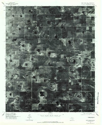
Agricultural patterns and the distinct playa lake basins of the Texas South Plains define this 1976 orthophotoquad. The landscape is dominated by the geometric precision of center-pivot irrigation and terraced fields, reflecting the intensive cotton and grain farming characteristic of the region. Amidst this high-production acreage, the small community of Slide serves as the primary focal point of settlement. The orthophoto format provides a clear, unvarnished look at the physical terrain as it existed in the mid-1970s, showing the numerous natural depressions or 'playas' that dot the landscape and collect seasonal runoff. This view captures the rural infrastructure of Lubbock County just as modern irrigation technology was fully reshaping the local economy and land use.
Find a feature on this map
1 named feature on this map. Tap any name to fly to it.
Don’t see what you’re looking for? This feature index may not catch every label — zoom into the map to look around manually.
Map Details
Editions of this 1976 New Home NW Map
2 editions found
Other maps of this area

1954 · Lubbock
USGS Topo · 1:250,000

1954 · Brownfield
USGS Topo · 1:250,000

1957 · Lubbock East
USGS Topo · 1:24,000

1957 · New Home
USGS Topo · 1:62,500

1957 · Lubbock West
USGS Topo · 1:24,000

1957 · Lubbock
USGS Topo · 1:62,500

1957 · Meadow
USGS Topo · 1:62,500

1957 · Wolfforth
USGS Topo · 1:62,500

1958 · Brownfield
USGS Topo · 1:250,000

1962 · Brownfield
USGS Topo · 1:250,000