
1969 Map of New Hope
USGS Topo · Published 1972About this map
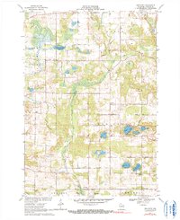
Nelsonville and the surrounding township of New Hope are defined by a complex network of glacial kettle lakes and the winding course of the Tomorrow River. This 1969 survey captures a rural landscape where community life centers on local institutions like the St Adalbert Sch and the distinct congregations at North New Hope Ch and South New Hope Ch. The topography reveals the intricate drainage patterns of Poncho Creek and Trout Creek, feeding into numerous water bodies such as Sunset Lake and Rinehart Lake.
Find a feature on this map
41 named features on this map. Tap any name to fly to it.
Don’t see what you’re looking for? This feature index may not catch every label — zoom into the map to look around manually.
Map Details
Editions of this 1969 New Hope Map
2 editions found
Other maps of this area

1955 · Tigerton
USGS Topo · 1:48,000

1955 · Rosholt
USGS Topo · 1:48,000

1955 · Green Bay
USGS Topo · 1:250,000

1957 · Amherst
USGS Topo · 1:48,000

1957 · Waupaca
USGS Topo · 1:48,000

1969 · Rosholt
USGS Topo · 1:24,000

1969 · Arnott
USGS Topo · 1:24,000

1969 · Rosholt NW
USGS Topo · 1:24,000
1969 · Scandinavia
USGS Topo · 1:24,000
1969 · Polonia
USGS Topo · 1:24,000