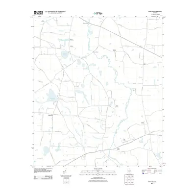
2011 Map of New Lois
USGS Topo · Published 2011About this map
The Withlacoochee River carves a winding path through this South Georgia landscape, defining the character of the countryside near the community of New Lois. This 2011 survey reveals a rural network of county roads and family-named landmarks, such as Daniels Cemetery and Wilkes Cemetery, that offer significant value for genealogists tracing local lineage. The topography is defined by numerous water bodies and drainage systems, including Hutchinson Pond and the Hutchinson Mill Creek, which suggest the historic importance of local water resources and milling. Notable social and recreational sites such as Camp Tygart and the Boys Ranch are situated along the river's eastern banks, while several spans like Futchs Bridge and Hagan Bridge provide essential crossings for the agricultural and residential traffic connecting Fellowship to the wider county.
Find a feature on this map
78 named features on this map. Tap any name to fly to it.
Don’t see what you’re looking for? This feature index may not catch every label — zoom into the map to look around manually.
Map Details
Editions of this 2011 New Lois Map
This is the sole edition of this map. No revisions or reprints were ever made.
Other maps of this area

1953 · Waycross
USGS Topo · 1:250,000

1954 · Valdosta
USGS Topo · 1:250,000

1958 · Valdosta
USGS Topo · 1:250,000

1958 · Waycross
USGS Topo · 1:250,000

1959 · Valdosta
USGS Topo · 1:250,000

1961 · Hahira East
USGS Topo · 1:24,000

1961 · Hahira West
USGS Topo · 1:24,000
1971 · Bemiss
USGS Topo · 1:24,000

1973 · Adel
USGS Topo · 1:24,000

1973 · New Lois
USGS Topo · 1:24,000