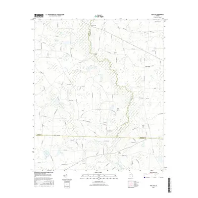
2017 Map of New Lois
USGS Topo · Published 2017About this map
The Withlacoochee River carves a winding path through the borderlands of Berrien, Cook, and Lowndes Counties, defining the agricultural and riparian character of this Georgia landscape. Near the settlement of New Lois, the terrain is marked by numerous family-named landmarks and historical burial grounds, including Wilkes Cem, Daniels Cem, and Baskins Cem. These sites, along with several ponds like Boyette Pond and Futchs Pond, indicate a long-standing pattern of rural land use where water resources and family homesteads are tightly linked. River crossings such as Williams Bridge, Futchs Bridge, and Hagan Bridge serve as vital connectors for the network of local roads including Old Lois Rd and Val Del Rd. The presence of Hutchinson Mill Cr suggests historical industry tied to the region's waterways, providing a rich map for those tracing genealogy or local land-use history in the Hahira area.
Find a feature on this map
110 named features on this map. Tap any name to fly to it.
Don’t see what you’re looking for? This feature index may not catch every label — zoom into the map to look around manually.
Map Details
Editions of this 2017 New Lois Map
This is the sole edition of this map. No revisions or reprints were ever made.
Other maps of this area

1953 · Waycross
USGS Topo · 1:250,000

1954 · Valdosta
USGS Topo · 1:250,000

1958 · Valdosta
USGS Topo · 1:250,000

1958 · Waycross
USGS Topo · 1:250,000

1959 · Valdosta
USGS Topo · 1:250,000

1961 · Hahira East
USGS Topo · 1:24,000

1961 · Hahira West
USGS Topo · 1:24,000
1971 · Bemiss
USGS Topo · 1:24,000

1973 · Adel
USGS Topo · 1:24,000

1973 · New Lois
USGS Topo · 1:24,000