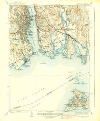
1938 Map of New London
USGS Topo · Published 1938About this map
The Thames River serves as the busy maritime corridor between New London and Groton in this mid-1930s survey. This coastal landscape is heavily defined by its nautical and military installations, featuring the U S Coast Guard Academy, the State Pier, and the Fort Trumbull C G Base guarding the harbor entrance. On the eastern shore, the Sheneccossett Country Club and Trumbull Airport occupy the coastal plain, while the New York New Haven and Hartford railroad cuts through the center of Groton and Poquonock Bridge.
Find a feature on this map
110 named features on this map. Tap any name to fly to it.
Don’t see what you’re looking for? This feature index may not catch every label — zoom into the map to look around manually.
Map Details
Editions of this 1938 New London Map
3 editions found

Other maps of this area

1889 · Stonington
USGS Topo · 1:62,500

1892 · New London
USGS Topo · 1:62,500

1893 · Stonington
USGS Topo · 1:62,500

1893 · New London
USGS Topo · 1:62,500

1903 · Gardiners Island
USGS Topo · 1:62,500

1904 · Gardiners Island
USGS Topo · 1:62,500

1904 · Montauk
USGS Topo · 1:62,500

1921 · Gardiners Island
USGS Topo · 1:62,500

1921 · New London
USGS Topo · 1:62,500

1921 · Stonington
USGS Topo · 1:62,500