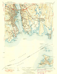
1938 Map of New London
USGS Topo · Published 1951About this map
New London and Groton serve as the maritime heart of this coastal survey, flanking the deep channel of the Thames River as it empties into Long Island Sound. The area's strategic naval importance is evident at Fort Trumbull USN Reservation and the Conn Nautical Sch, while across the water, Groton Heights and Poquonock Bridge mark the expanding residential and industrial footprint of the eastern shore. The coastal landscape is dotted with navigation aids like the New London Harbor Lighthouse and New London Ledge Lighthouse.
Find a feature on this map
100 named features on this map. Tap any name to fly to it.
Don’t see what you’re looking for? This feature index may not catch every label — zoom into the map to look around manually.
Map Details
Editions of this 1938 New London Map
3 editions found

Other maps of this area

1889 · Stonington
USGS Topo · 1:62,500

1892 · New London
USGS Topo · 1:62,500

1893 · Stonington
USGS Topo · 1:62,500

1893 · New London
USGS Topo · 1:62,500

1903 · Gardiners Island
USGS Topo · 1:62,500

1904 · Gardiners Island
USGS Topo · 1:62,500

1904 · Montauk
USGS Topo · 1:62,500

1921 · Gardiners Island
USGS Topo · 1:62,500

1921 · New London
USGS Topo · 1:62,500

1921 · Stonington
USGS Topo · 1:62,500