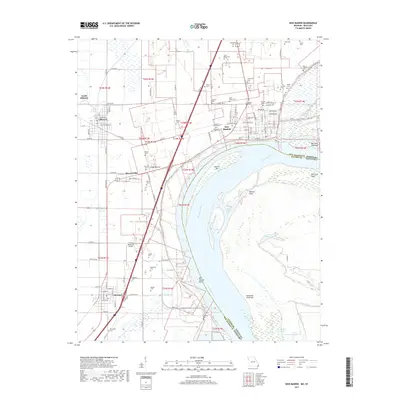
2017 Map of New Madrid
USGS Topo · Published 2017About this map
New Madrid occupies the north bank of a dramatic oxbow on the Mississippi River, where the New Madrid Bend forces the water into a tight southward loop. This landscape is shaped by the river's massive alluvial shifts, evidenced by features like Madrid Bar and Kentucky Point Bar. The map reveals a high density of rural burial grounds, including the Sand Hill Cem and Evergreen Cem, which often cluster near early homesteads or established parishes like Saint Marys Cem. A significant archaeological marker, the Indian Mound, sits just south of Howardville, while the BNSF Railway and County Memorial Airport trace the modern transit corridors through this flood-prone region. From Lilbourn to Marston, the grid of agricultural drainage and country roads defines the flat bottomlands of the Missouri Bootheel.
Find a feature on this map
123 named features on this map. Tap any name to fly to it.
Don’t see what you’re looking for? This feature index may not catch every label — zoom into the map to look around manually.
Map Details
Editions of this 2017 New Madrid Map
This is the sole edition of this map. No revisions or reprints were ever made.
Other maps of this area

1925 · Reelfoot Lake
USGS Topo · 1:62,500

1939 · Reelfoot Lake
USGS Topo · 1:62,500

1939 · Portageville
USGS Topo · 1:62,500

1939 · New Madrid
USGS Topo · 1:62,500

1939 · Bayouville
USGS Topo · 1:62,500

1951 · New Madrid SE
USGS Topo · 1:24,000

1951 · Hubbard Lake
USGS Topo · 1:24,000

1954 · New Madrid
USGS Topo · 1:62,500

1955 · Portageville
USGS Topo · 1:62,500

1955 · Bayouville
USGS Topo · 1:62,500