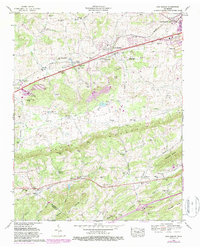
1961 Map of New Market
USGS Topo · Published 1987About this map
Mining operations and rural settlements define this corridor of East Tennessee between Jefferson City and New Market. The landscape is dominated by industrial infrastructure including the North Friends Station Mine, Grasselli Mine, and Young Mine, along with large tailings ponds that mark the region's zinc mining legacy. These industrial sites sit in close proximity to long-standing community landmarks like Friends Station and the Wooten Chapel church and cemetery.
Find a feature on this map
74 named features on this map. Tap any name to fly to it.
Don’t see what you’re looking for? This feature index may not catch every label — zoom into the map to look around manually.
Map Details
Editions of this 1961 New Market Map
3 editions found
Other maps of this area

1883 · Morristown
USGS Topo · 1:125,000

1886 · Knoxville
USGS Topo · 1:125,000

1892 · Knoxville
USGS Topo · 1:125,000

1893 · Mt Guyot
USGS Topo · 1:125,000

1893 · Morristown
USGS Topo · 1:125,000

1894 · Knoxville
USGS Topo · 1:125,000

1895 · Morristown
USGS Topo · 1:125,000

1895 · Knoxville
USGS Topo · 1:125,000

1897 · Maynardville
USGS Topo · 1:125,000

1900 · Maynardville
USGS Topo · 1:125,000