1951 Map of New Market
USGS Topo · Published 1951About this map
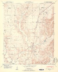
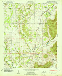
New Market and the surrounding agricultural valleys of northern Madison County are captured in this mid-century survey, defined by the winding course of the Flint River and the rugged profile of Backbone Mountain. The landscape is heavily marked by small rural communities and the Nashville Chattanooga and St Louis railway, which connects points like Plevna and Steele Crossing. A significant historical landmark, the Old Cherokee Boundary, cuts diagonally across the eastern terrain, reflecting earlier territorial divisions.
Find a feature on this map
66 named features on this map. Tap any name to fly to it.
Don’t see what you’re looking for? This feature index may not catch every label — zoom into the map to look around manually.
Map Details
Editions of this 1951 New Market Map
2 editions found
Other maps of this area

1888 · Scottsboro
USGS Topo · 1:125,000

1888 · Huntsville
USGS Topo · 1:125,000

1892 · Huntsville
USGS Topo · 1:125,000

1892 · Scottsboro
USGS Topo · 1:125,000

1936 · King Cove
USGS Topo · 1:24,000
1936 · Flintville
USGS Topo · 1:24,000

1936 · Meridianville
USGS Topo · 1:24,000

1936 · Fisk
USGS Topo · 1:24,000

1936 · Hollytree
USGS Topo · 1:24,000

1936 · Lincoln
USGS Topo · 1:24,000