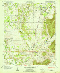
1951 Map of New Market
USGS Topo · Published 1951About this map
The settlement of New Market serves as the hub of this mid-century survey, where the Nashville Chattanooga and St Louis Railway cuts through the landscape near the Flint River. This area along the Tennessee-Alabama border is defined by a dense network of early rural institutions, including the Hopewell Ch Mountain Fork School, Plevna School, and numerous community houses of worship such as St Pauls Ch and Zion Progress Church.
Find a feature on this map
61 named features on this map. Tap any name to fly to it.
Don’t see what you’re looking for? This feature index may not catch every label — zoom into the map to look around manually.
Map Details
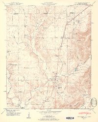
Editions of this 1951 New Market Map
2 editions found
Other maps of this area

1888 · Scottsboro
USGS Topo · 1:125,000

1888 · Huntsville
USGS Topo · 1:125,000

1892 · Huntsville
USGS Topo · 1:125,000

1892 · Scottsboro
USGS Topo · 1:125,000

1936 · King Cove
USGS Topo · 1:24,000
1936 · Flintville
USGS Topo · 1:24,000

1936 · Meridianville
USGS Topo · 1:24,000

1936 · Fisk
USGS Topo · 1:24,000

1936 · Hollytree
USGS Topo · 1:24,000

1936 · Lincoln
USGS Topo · 1:24,000