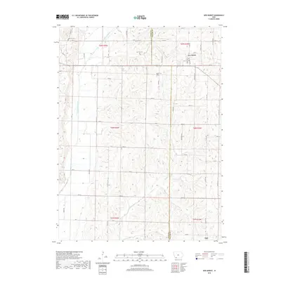
2018 Map of New Market
USGS Topo · Published 2018About this map
New Market anchors the northeastern portion of this Taylor County landscape, situated where Co Rd N26 and 8th St intersect. The terrain is defined by the winding course of the East Nodaway River in the west and the dendritic drainage of Buchanan Cr through the central and southern sections. This area of southwest Iowa preserves a strong genealogical record through its scattered rural burial grounds, including Aron View Cem and Vise Cem located north of the primary settlement. Further south, the community of Siam sits near the border of Page and Taylor counties, marking a localized hub in an otherwise agricultural grid. The map detail highlights the transition from river bottomlands to the upland ridges that separate these local creek valleys.
Find a feature on this map
54 named features on this map. Tap any name to fly to it.
Don’t see what you’re looking for? This feature index may not catch every label — zoom into the map to look around manually.
Map Details
Editions of this 2018 New Market Map
This is the sole edition of this map. No revisions or reprints were ever made.
Other maps of this area

1940 · Coin
USGS Topo · 1:62,500

1940 · New Market
USGS Topo · 1:62,500

1943 · Coin
USGS Topo · 1:62,500

1943 · New Market
USGS Topo · 1:62,500

1955 · Nebraska City
USGS Topo · 1:250,000

1957 · Nebraska City
USGS Topo · 1:250,000

1958 · Nebraska City
USGS Topo · 1:250,000

1978 · Clarinda North
USGS Topo · 1:24,000
1980 · Hopkins SW
USGS Topo · 1:24,000

1980 · Guss
USGS Topo · 1:24,000