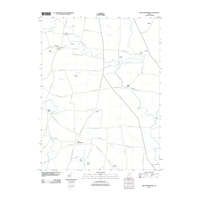
2010 Map of New Martinsburg
USGS Topo · Published 2010About this map
Staunton and New Martinsburg anchor this rural landscape in Fayette County, where small agricultural settlements are connected by a network of named country roads and winding waterways. The terrain is defined by the drainage of Paint Creek, Sugar Creek, and Rattlesnake Creek, which cut across the farm fields. A high density of family and community burial grounds, such as Hyer Cemetery, Carmean Cemetery, and the curiously named Sheep Pen Cemetery, offers significant value for genealogical research and tracing the early pioneer families of the township.
Find a feature on this map
63 named features on this map. Tap any name to fly to it.
Don’t see what you’re looking for? This feature index may not catch every label — zoom into the map to look around manually.
Map Details
Editions of this 2010 New Martinsburg Map
This is the sole edition of this map. No revisions or reprints were ever made.
Other maps of this area

1906 · Mt Sterling
USGS Topo · 1:62,500

1916 · Octa
USGS Topo · 1:62,500

1917 · Greenfield
USGS Topo · 1:62,500

1917 · Sabina
USGS Topo · 1:62,500

1943 · Sabina
USGS Topo · 1:62,500

1944 · Greenfield
USGS Topo · 1:62,500

1944 · Octa
USGS Topo · 1:62,500

1947 · Columbus
USGS Topo · 1:250,000

1960 · Greenfield
USGS Topo · 1:24,000
1960 · Good Hope
USGS Topo · 1:24,000