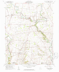
1960 Map of New Martinsburg
USGS Topo · Published 1962About this map
Paint Creek carves a deep, winding valley through the center of this landscape, creating a sharp contrast between the level upland farms and the steep, wooded bluffs of Wayne and Perry townships. The local economy in the early 1960s is defined by small agricultural hubs like New Martinsburg and Staunton, and the industrial presence of the Detroit Toledo and Ironton RR cutting across the northeast. Numerous small burial grounds, including the Catmean Cem, Hyer Cem, and Archer Cem, are scattered across the landscape, often situated on high ground overlooking the drainage basins of Sugar Creek and Rattlesnake Creek. The map documents a traditional rural network of schools and mills, such as Township Sch and Rock Mills, providing a clear look at the settlement patterns along the Fayette and Highland County line before modern highway expansion.
Find a feature on this map
52 named features on this map. Tap any name to fly to it.
Don’t see what you’re looking for? This feature index may not catch every label — zoom into the map to look around manually.
Map Details
Editions of this 1960 New Martinsburg Map
This is the sole edition of this map. No revisions or reprints were ever made.
Other maps of this area

1906 · Mt Sterling
USGS Topo · 1:62,500

1916 · Octa
USGS Topo · 1:62,500

1917 · Greenfield
USGS Topo · 1:62,500

1917 · Sabina
USGS Topo · 1:62,500

1943 · Sabina
USGS Topo · 1:62,500

1944 · Greenfield
USGS Topo · 1:62,500

1944 · Octa
USGS Topo · 1:62,500

1947 · Columbus
USGS Topo · 1:250,000

1960 · Greenfield
USGS Topo · 1:24,000
1960 · Good Hope
USGS Topo · 1:24,000