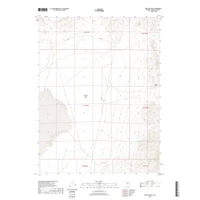
2018 Map of New Pass Well
USGS Topo · Published 2018About this map
Edwards Creek Valley dominates this Churchill County landscape, forming a wide alluvial expanse bounded on the east by the rising contours of the New Pass Range. This 2018 survey reveals a sparse, high-desert environment defined by essential water points and basic transport infrastructure. The eponymous New Pass Well stands as a critical landmark for the area's history, situated near the intersection of several local routes. Significant thoroughfares like Alpine N Rd, Alpine E, and the distinctly named Hay Stacks trace the valley floor, highlighting the minimal yet vital road network required to navigate this remote Great Basin terrain. The map's detailed grid, including sections of t21n r39e and t22n r40e, provides an essential framework for understanding land tenure and historical ranching or mining access within the basin.
Find a feature on this map
12 named features on this map. Tap any name to fly to it.
Don’t see what you’re looking for? This feature index may not catch every label — zoom into the map to look around manually.
Map Details
Editions of this 2018 New Pass Well Map
This is the sole edition of this map. No revisions or reprints were ever made.
Other maps of this area

1955 · Millett
USGS Topo · 1:250,000

1959 · Millett
USGS Topo · 1:250,000

1966 · Shoshone Meadows
USGS Topo · 1:62,500

1966 · Edwards Creek Valley
USGS Topo · 1:62,500

1969 · Mount Airy
USGS Topo · 1:24,000

1969 · Gilbert Creek SW
USGS Topo · 1:24,000

1969 · Mount Airy NW
USGS Topo · 1:24,000

1983 · Edwards Creek Valley
USGS Topo · 1:100,000

1990 · Byers Ranch
USGS Topo · 1:24,000
1990 · Shoshone Meadows
USGS Topo · 1:24,000