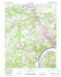
1957 Map of New Providence
USGS Topo · Published 1981About this map
The Fort Campbell Military Reservation dominates the northwestern portion of this landscape, its boundary bordering suburban expansion in Montgomery County. This 1957 survey captures the post-war growth of Clarksville, particularly in the developments of Bel-Air Estates and Park Lane. The Cumberland River Lake Barkley snakes through the southern reaches, providing a vital waterway alongside rural settlements such as Liberty and Sunnyview.
Find a feature on this map
34 named features on this map. Tap any name to fly to it.
Don’t see what you’re looking for? This feature index may not catch every label — zoom into the map to look around manually.
Map Details
Editions of this 1957 New Providence Map
4 editions found
Other maps of this area

1931 · Erin
USGS Topo · 1:62,500

1944 · Clarksville
USGS Topo · 1:50,000

1951 · New Providence
USGS Topo · 1:24,000

1951 · Hammacksville
USGS Topo · 1:24,000

1951 · Clarksville
USGS Topo · 1:24,000

1951 · Herndon
USGS Topo · 1:24,000

1951 · Oak Grove
USGS Topo · 1:24,000

1951 · Woodlawn
USGS Topo · 1:24,000

1956 · Nashville
USGS Topo · 1:250,000

1957 · New Providence
USGS Topo · 1:24,000
Featured Places
- Clarksville, TN
- Briarwood, TN
- Belleglade Mobile Home Community, Clarksville
- Sherwood Forest, Clarksville
- New Providence, Clarksville