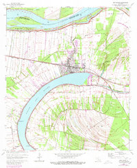
1962 Map of New Roads
USGS Topo · Published 1980About this map
False River, an oxbow lake of the Mississippi River, dominates the landscape of this Pointe Coupee Parish survey. The town of New Roads serves as the focal point, situated on the northern bank of the oxbow and bisected by the Texas and Pacific railroad. The map illustrates a dense pattern of long-lot land divisions radiating from the water, characteristic of colonial French settlement patterns where river access was paramount.
Find a feature on this map
36 named features on this map. Tap any name to fly to it.
Don’t see what you’re looking for? This feature index may not catch every label — zoom into the map to look around manually.
Map Details
Editions of this 1962 New Roads Map
4 editions found
Other maps of this area

1906 · Bayou Sara
USGS Topo · 1:125,000

1939 · St. Francisville
USGS Topo · 1:62,500

1939 · Fordoche
USGS Topo · 1:62,500

1941 · Batchelor
USGS Topo · 1:62,500

1953 · New Roads
USGS Topo · 1:24,000

1954 · Port Hudson
USGS Topo · 1:24,000

1954 · Walls
USGS Topo · 1:24,000

1954 · Elm Park
USGS Topo · 1:24,000

1954 · Fordoche
USGS Topo · 1:24,000

1954 · Erwinville
USGS Topo · 1:24,000