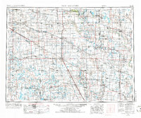
1952 Map of New Rockford
USGS Topo · Published 1986About this map
Fort Totten Indian Reservation and the surrounding plains of central North Dakota are depicted here during a period of established agricultural and rail activity. The landscape is characterized by a high density of small-town grain stops and sidings along the Northern Pacific RR, Great Northern RR, and Soo Line RR. Prominent landmarks such as Butte De Morale and Black Hammer Hill rise above the terrain, while the extensive system of glacial lakes and wetlands, including Devils Lake and Stump Lake, provide natural focal points for the region. Significant conservation areas like Sullys Hill National Game Preserve and Arrowwood National Wildlife Refuge indicate the early preservation of local prairie habitats. The rail-centric settlement pattern is evident in the string of communities like New Rockford, Fessenden, and Carrington that served as vital hubs for the local agrarian economy.
Find a feature on this map
134 named features on this map. Tap any name to fly to it.
Don’t see what you’re looking for? This feature index may not catch every label — zoom into the map to look around manually.
Map Details
Editions of this 1952 New Rockford Map
3 editions found

Other maps of this area

1896 · Jamestown
USGS Topo · 1:125,000

1897 · Tower
USGS Topo · 1:125,000

1897 · Eckelson
USGS Topo · 1:125,000

1900 · Pingree
USGS Topo · 1:125,000

1900 · Pingree
USGS Topo · 1:62,500

1928 · Tokio
USGS Topo · 1:62,500

1930 · Pekin
USGS Topo · 1:62,500

1930 · Hamar
USGS Topo · 1:62,500

1931 · Oberon
USGS Topo · 1:62,500

1931 · Tokio
USGS Topo · 1:62,500