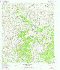
1963 Map of New Ulm
USGS Topo · Published 1982About this map
The rolling prairies of West Texas are defined here by the headwaters of the West Mill Creek system and the Missouri Kansas Texas railroad corridor. This landscape is a patchwork of German-Texan heritage, anchored by the town of New Ulm and the outlying community of Industry. The map reveals a dense distribution of rural burial sites, including the National Cem, Zettle Cem, and Star Hill Cem, which serve as vital markers for family historians and genealogists. Local industry and land use are evident through the New Ulm Oil Field and the numerous pipelines that traverse the terrain near New Bremen. The complex network of watercourses, such as Black Walnut Creek and Meckelroy Branch, suggests the historical importance of drainage and reliable water in this agricultural region during the early 1960s.
Find a feature on this map
36 named features on this map. Tap any name to fly to it.
Don’t see what you’re looking for? This feature index may not catch every label — zoom into the map to look around manually.
Map Details
Editions of this 1963 New Ulm Map
2 editions found
Other maps of this area

1919 · Fayettsville
USGS Topo · 1:62,500

1930 · Brenham
USGS Topo · 1:62,500

1953 · Seguin
USGS Topo · 1:250,000

1954 · Austin
USGS Topo · 1:250,000

1956 · Bellville
USGS Topo · 1:62,500

1956 · Brenham
USGS Topo · 1:62,500

1958 · Seguin
USGS Topo · 1:250,000

1958 · Industry
USGS Topo · 1:24,000

1958 · Greenvine
USGS Topo · 1:24,000

1958 · Frelsburg
USGS Topo · 1:24,000