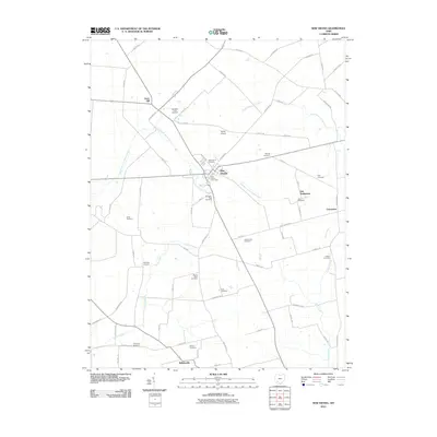
2010 Map of New Vienna
USGS Topo · Published 2010About this map
New Vienna serves as the central hub for this southwestern Ohio landscape, where the East Fork Little Miami River begins its course through fertile agricultural lands. The map reveals a dense concentration of family and community burial grounds, such as the Swingsley Farm Cemetery and Achor Cemetery, which provide invaluable reference points for genealogical research. Notable for its local history, the area includes the Gist Settlement and its associated Gist Cemetery, representing a significant mid-19th-century land grant for emancipated people. Smaller crossroads and rural landmarks, including Careytown and Terrell Airport, are connected by a grid of farm-to-market roads like Nordike Rd and Mad River Rd. The terrain is further defined by the headwaters of Turtle Creek and Clear Creek, tracing the drainage patterns that have shaped the region's development since early settlement.
Find a feature on this map
66 named features on this map. Tap any name to fly to it.
Don’t see what you’re looking for? This feature index may not catch every label — zoom into the map to look around manually.
Map Details
Editions of this 2010 New Vienna Map
This is the sole edition of this map. No revisions or reprints were ever made.
Other maps of this area

1907 · Blanchester
USGS Topo · 1:62,500

1917 · Hillsboro
USGS Topo · 1:62,500

1917 · Sabina
USGS Topo · 1:62,500

1917 · Sardinia
USGS Topo · 1:62,500

1943 · Sabina
USGS Topo · 1:62,500

1944 · Hillsboro
USGS Topo · 1:62,500

1944 · Sardinia
USGS Topo · 1:62,500

1947 · Columbus
USGS Topo · 1:250,000
1960 · Lynchburg
USGS Topo · 1:24,000

1960 · Martinsville
USGS Topo · 1:24,000