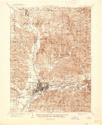
1909 Map of Newark
USGS Topo · Published 1946About this map
Newark serves as the industrial and transportation hub of this early 20th-century landscape, where the Licking River and its various forks converge. The map documents a period of significant transition in Ohio transit, showing the established routes of the Pennsylvania RR and Baltimore and Ohio RR alongside the early obsolescence of electric lines, such as the Ohio Electric Ry (Abandoned) and the St L and Columbus RR (Abandoned). Outside the city center, a dense network of rural one-room schoolhouses like Blackhawk School and Forest Glen School dot the townships of Mary Ann and Fallsbury.
Find a feature on this map
80 named features on this map. Tap any name to fly to it.
Don’t see what you’re looking for? This feature index may not catch every label — zoom into the map to look around manually.
Map Details
Editions of this 1909 Newark Map
2 editions found
Other maps of this area

1907 · Thurston
USGS Topo · 1:62,500

1908 · Granville
USGS Topo · 1:62,500

1909 · Newark
USGS Topo · 1:62,500

1909 · Thornville
USGS Topo · 1:62,500

1909 · Thurston
USGS Topo · 1:62,500

1910 · Frazeysburg
USGS Topo · 1:62,500

1910 · Zanesville
USGS Topo · 1:62,500

1910 · Granville
USGS Topo · 1:62,500

1912 · Gambier
USGS Topo · 1:62,500

1913 · Brinkhaven
USGS Topo · 1:62,500