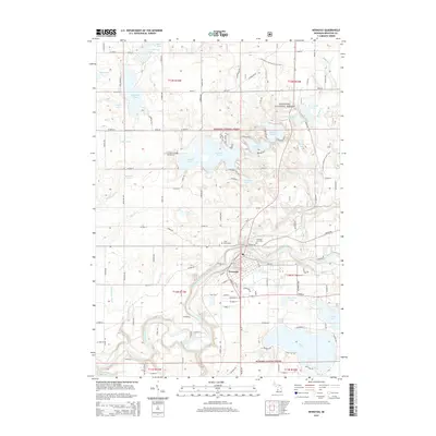
2014 Map of Newaygo
USGS Topo · Published 2014About this map
The Muskegon River winds through the heart of the settlement of Newaygo, serving as a central geographic feature in this portion of West Michigan. In the northern and eastern reaches of the sheet, the Manistee National Forest provides a backdrop for a landscape dotted with countless water bodies, including Hess Lake, Pickerel Lake, and Brooks Lake. The topography is defined by these glacial lakes and the drainage systems of Brooks Cr and Penoyer Cr. For those interested in local history and genealogy, the map identifies the Newaygo City Cem and Saint Marks Cem near the town center. Long-distance recreation is represented by the N Country National Scenic Trail, which traverses the wooded sections north of the river, while the road network connects the residential developments surrounding Sylvan Lake and Emerald Lake.
Find a feature on this map
134 named features on this map. Tap any name to fly to it.
Don’t see what you’re looking for? This feature index may not catch every label — zoom into the map to look around manually.
Map Details
Editions of this 2014 Newaygo Map
This is the sole edition of this map. No revisions or reprints were ever made.
Other maps of this area

1954 · Midland
USGS Topo · 1:250,000

1958 · Midland
USGS Topo · 1:250,000

1958 · Sand Lake
USGS Topo · 1:62,500

1958 · Fremont
USGS Topo · 1:62,500

1958 · Woodville
USGS Topo · 1:62,500

1959 · Midland
USGS Topo · 1:250,000

1959 · White Cloud
USGS Topo · 1:62,500

1966 · Midland
USGS Topo · 1:250,000
1976 · White Cloud SW
USGS Topo · 1:24,000

1976 · White Cloud SE
USGS Topo · 1:24,000