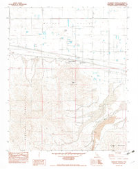
1982 Map of Newberry Springs
USGS Topo · Published 1982About this map
Newberry Springs sits at the intersection of the arid Mojave Valley and the rising elevations of the Newberry Mountains. This early 1980s survey captures a landscape defined by significant geologic transitions and infrastructure, where the namesake Newberry Spring is noted as dry, reflecting the desert environment. To the south, the topography becomes complex with landmarks such as Newberry Peak and Newberry Cairn, leading toward the Rodman Mountains.
Find a feature on this map
16 named features on this map. Tap any name to fly to it.
Don’t see what you’re looking for? This feature index may not catch every label — zoom into the map to look around manually.
Map Details
Editions of this 1982 Newberry Springs Map
2 editions found
Other maps of this area

1953 · San Bernardino
USGS Topo · 1:250,000

1953 · Yermo
USGS Topo · 1:24,000

1955 · Silver Bell Mine
USGS Topo · 1:24,000

1955 · Newberry
USGS Topo · 1:62,500

1955 · Ord Mountains
USGS Topo · 1:62,500

1955 · Rodman Mountains
USGS Topo · 1:62,500

1956 · San Bernardino
USGS Topo · 1:250,000

1956 · Daggett
USGS Topo · 1:62,500

1957 · San Bernardino
USGS Topo · 1:250,000

1958 · San Bernardino
USGS Topo · 1:250,000