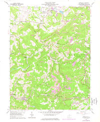
1960 Map of Newburg
USGS Topo · Published 1977About this map
The planned community of Arthurdale occupies the northern reaches of this Preston County landscape, characterized by the systematic layout of homes and communal facilities like Arthurdale Sch. Further south, the coal-driven economy of the 1960s is evidenced by a dense concentration of Strip Mine and Strip Mines operations that terrace the hillsides above Raccoon Creek. The transport infrastructure is dominated by the Baltimore and Ohio railroad corridor, which links the industrial settlements of Newburg and Tunnelton through a series of rugged Tunnels.
Find a feature on this map
57 named features on this map. Tap any name to fly to it.
Don’t see what you’re looking for? This feature index may not catch every label — zoom into the map to look around manually.
Map Details
Editions of this 1960 Newburg Map
4 editions found
Other maps of this area

1886 · St. George
USGS Topo · 1:125,000

1891 · St. George
USGS Topo · 1:125,000

1902 · Morgantown
USGS Topo · 1:62,500

1904 · Bruceton
USGS Topo · 1:62,500

1907 · Thornton
USGS Topo · 1:62,500

1907 · Kingwood
USGS Topo · 1:62,500

1925 · Kingwood
USGS Topo · 1:62,500

1925 · Morgantown
USGS Topo · 1:62,500

1926 · Thornton
USGS Topo · 1:62,500

1926 · Bruceton
USGS Topo · 1:62,500