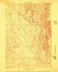
1901 Map of Newcastle
USGS Topo · Published 1911About this map
Newcastle and the rugged canyonlands of the Wyoming-South Dakota border are meticulously documented in this turn-of-the-century survey. The landscape is defined by the Burlington and Missouri River R. R., which winds through the hills to serve early settlements like Cambria and Osage. The eastern portion of the map is dominated by the Black Hills Forest Reserve, where elevations rise toward Elk Mt and Fanny Peak. Numerous cattle operations, including the YT Ranch, LAK Ranch, and S and G Ranch, point to the region's ranching foundations during this era. A complex network of drainage systems, such as Beaver Creek and Oil Creek, dictates the movement and settlement patterns of early homesteaders. Small rail stops like Spencer Siding and Pedro further illustrate the early industrial and transit development required to connect these high-plains outposts to the rest of the frontier.
Find a feature on this map
46 named features on this map. Tap any name to fly to it.
Don’t see what you’re looking for? This feature index may not catch every label — zoom into the map to look around manually.
Map Details
Editions of this 1901 Newcastle Map
3 editions found
Other maps of this area

1894 · Deadwood
USGS Topo · 1:125,000

1896 · Harney Peak
USGS Topo · 1:125,000

1898 · Sundance
USGS Topo · 1:125,000

1899 · Newcastle
USGS Topo · 1:125,000

1901 · Harney Peak
USGS Topo · 1:125,000

1901 · Deadwood
USGS Topo · 1:125,000

1901 · Newcastle
USGS Topo · 1:125,000

1902 · Sundance
USGS Topo · 1:125,000

1902 · Edgemont
USGS Topo · 1:125,000

1916 · Deadwood
USGS Topo · 1:125,000