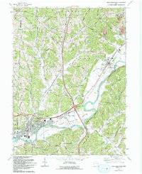
1993 Map of Newcomerstown
USGS Topo · Published 1993About this map
The Tuscarawas River carves a winding path through this corner of the state, defining the industrial and agricultural landscape of Newcomerstown. This map illustrates the intersection of mid-century infrastructure and historic land divisions, notably the Stark Patent and Oxford township lines. In the municipal center, the Cy Young Memorial Park honors the legendary pitcher who called this area home. The town's layout is grounded by its educational and spiritual centers, including East Sch, Middle Sch, and West Sch, alongside several historic burial grounds such as Union Cem.
Find a feature on this map
65 named features on this map. Tap any name to fly to it.
Don’t see what you’re looking for? This feature index may not catch every label — zoom into the map to look around manually.
Map Details
Editions of this 1993 Newcomerstown Map
This is the sole edition of this map. No revisions or reprints were ever made.
Other maps of this area

1909 · Antrim
USGS Topo · 1:48,000

1909 · Uhrichsville
USGS Topo · 1:62,500

1909 · Cambridge
USGS Topo · 1:62,500

1911 · Antrim
USGS Topo · 1:62,500

1911 · Uhrichsville
USGS Topo · 1:62,500

1911 · Newcomerstown
USGS Topo · 1:62,500

1912 · Cambridge
USGS Topo · 1:62,500

1913 · Newcomerstown
USGS Topo · 1:62,500

1943 · Newcomerstown
USGS Topo · 1:62,500

1951 · Canton
USGS Topo · 1:250,000