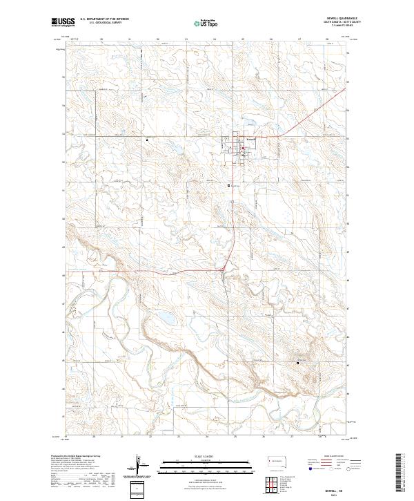
2021 Map of Newell
USGS Topo · Published 2021About this map
Newell serves as the central hub of this northern plains landscape, where a dense network of man-made waterways illustrates the region's historical reliance on managed irrigation. The map reveals a complex system of canals and laterals, including the N Canal, S Canal, and Long Canal, which branch out to support local agriculture. This hydraulic engineering is juxtaposed with natural drainages like Deadman Cr and Whitewood Cr. To the south, the Belle Fourche River meanders across the territory, joined by tributaries such as Horse Cr and Cottonwood Cr. Genealogists and local historians will find value in the placement of several small burial grounds, notably Maass Cem northwest of town and Newell Cem just to its south, alongside Wilson Cem further southeast. The layout of rural roads, such as Experimental Farm Rd and Viken Rd, reflects the systematic sectioning of the Butte County countryside.
Find a feature on this map
79 named features on this map. Tap any name to fly to it.
Don’t see what you’re looking for? This feature index may not catch every label — zoom into the map to look around manually.
Map Details
Editions of this 2021 Newell Map
This is the sole edition of this map. No revisions or reprints were ever made.
Other maps of this area

1905 · Saint Onge
USGS Topo · 1:62,500

1906 · Two Top
USGS Topo · 1:62,500

1906 · Vale
USGS Topo · 1:62,500

1907 · Belle Fourche
USGS Topo · 1:125,000

1913 · Newell
USGS Topo · 1:125,000

1951 · Vale
USGS Topo · 1:24,000

1951 · Vale SE
USGS Topo · 1:24,000

1951 · Newell
USGS Topo · 1:24,000

1951 · Vale NE
USGS Topo · 1:24,000
1951 · Nisland
USGS Topo · 1:24,000