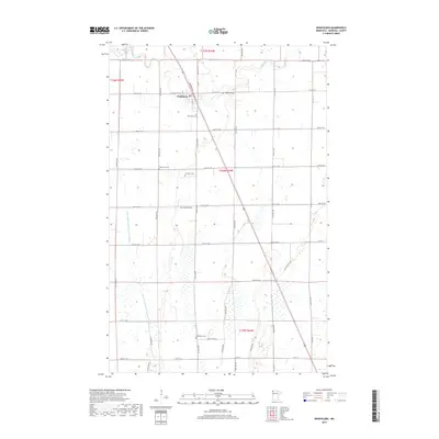
2019 Map of Newfolden
USGS Topo · Published 2019About this map
The Middle River winds through the northern portion of this Marshall County landscape, anchoring the settlement of Newfolden. This region is defined by its agricultural grid and an extensive water management system, most notably the Main Judicial Ditch Number Fifteen which runs vertically through the western sections. For genealogists and local historians, the map is remarkably dense with burial sites, identifying Augustana Cem, Oak Grove Cem, Westaker Cem, Sorenson Cem, Bjorsness Cem, and Bethlehem Cem. These sites are distributed across the townships, often associated with early family names and pioneer congregations. The transit corridor is marked by Railway St and Railroad St N, tracing the path of the rail line that spurred the town's development. The surrounding sections, such as t156n r44w, reveal a meticulously surveyed landscape of county roads and section lines typical of the Red River Valley's eastern edge.
Find a feature on this map
34 named features on this map. Tap any name to fly to it.
Don’t see what you’re looking for? This feature index may not catch every label — zoom into the map to look around manually.
Map Details
Editions of this 2019 Newfolden Map
This is the sole edition of this map. No revisions or reprints were ever made.
Other maps of this area

1918 · Viking
USGS Topo · 1:62,500

1918 · Middle River
USGS Topo · 1:62,500

1943 · Thief River Falls
USGS Topo · 1:62,500

1952 · Thief River Falls
USGS Topo · 1:250,000

1956 · Thief River Falls
USGS Topo · 1:250,000

1957 · Thief River Falls
USGS Topo · 1:250,000

1957 · Newfolden
USGS Topo · 1:62,500

1959 · Viking
USGS Topo · 1:24,000

1959 · Rosewood
USGS Topo · 1:24,000
1961 · Thief River Falls NW
USGS Topo · 1:24,000