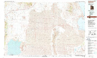
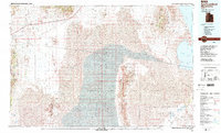
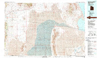
1988 Map of Newfoundland Mountains
USGS Topo · Published 1988About this map
Newfoundland Mountains rise sharply out of the vast expanses of the Mud Flat and the Great Salt Lake Desert, anchoring a landscape defined by isolation and military restricted zones. In the late 1980s, this region of western Utah remained sparsely populated, with the settlement of Lucin standing as a primary point of reference in the northwest. The terrain is marked by an extensive Old Railroad Grade that traces a legacy of western transit across the salt flats, while the southeastern portion of the map is dominated by the Hill Air Force Range.
Find a feature on this map
41 named features on this map. Tap any name to fly to it.
Don’t see what you’re looking for? This feature index may not catch every label — zoom into the map to look around manually.
Map Details
Editions of this 1988 Newfoundland Mountains Map
3 editions found
Other maps of this area

1885 · Tooele Valley
USGS Topo · 1:250,000

1953 · Tooele
USGS Topo · 1:250,000

1954 · Brigham City
USGS Topo · 1:250,000

1955 · Tooele
USGS Topo · 1:250,000

1955 · Wells
USGS Topo · 1:250,000

1955 · Elko
USGS Topo · 1:250,000

1958 · Wells
USGS Topo · 1:250,000

1958 · Elko
USGS Topo · 1:250,000

1958 · Brigham City
USGS Topo · 1:250,000

1961 · Wells
USGS Topo · 1:250,000