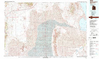
1988 Map of Newfoundland Mountains
USGS Topo · Published 1989About this map
The Newfoundland Mountains rise as a striking island of terrain surrounded by the expanse of the Great Salt Lake Desert and the Newfoundland Basin. This 1980s landscape is defined by the stark isolation of its desert ranges, including the Silver Island Mountains and the Hogup Mountains. Human presence is sparse, marked primarily by the Old Railroad Grade and the small settlements of Lucin and Jackson along the western periphery. The eastern portion of the map is dominated by the Utah Test and Training Range North Area, reflecting the region's mid-century military utility. Traces of historical industry and travel are visible in features like Miners Basin and Patterson Pass, while the hydrologic character of the basin is captured by the Mud Flat, Clyman Bay, and the shifting edges of the Great Salt Lake.
Find a feature on this map
49 named features on this map. Tap any name to fly to it.
Don’t see what you’re looking for? This feature index may not catch every label — zoom into the map to look around manually.
Map Details
Editions of this 1988 Newfoundland Mountains Map
3 editions found
Other maps of this area

1885 · Tooele Valley
USGS Topo · 1:250,000

1953 · Tooele
USGS Topo · 1:250,000

1954 · Brigham City
USGS Topo · 1:250,000

1955 · Tooele
USGS Topo · 1:250,000

1955 · Wells
USGS Topo · 1:250,000

1955 · Elko
USGS Topo · 1:250,000

1958 · Wells
USGS Topo · 1:250,000

1958 · Elko
USGS Topo · 1:250,000

1958 · Brigham City
USGS Topo · 1:250,000

1961 · Wells
USGS Topo · 1:250,000