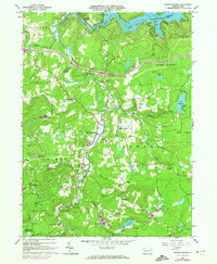
1966 Map of Newfoundland
USGS Topo · Published 1974About this map
Newfoundland serves as a central hub in this landscape where the Wayne Co Pike Co line bisects rural townships like Sterling and Greene. The area is defined by the massive reach of Lake Wallenpaupack to the north and the complex drainage of the Wallenpaupack Creek system, including its West Branch and East Branch. The 1970s updates reveal a transition toward recreation, evidenced by several campsites, a Golf Course, and Roadside Park along the shoreline, while the interior remains anchored by small traditional settlements such as Greentown and South Sterling. Local history is preserved in the location of Haag's Mill and several burial grounds including Pine Grove Cem and Zion Cem. High points like Panther Hill and Sugar Hill overlook a mosaic of state forest land and scattered gravel pits, reflecting the region's balance of natural preservation and local industry.
Find a feature on this map
53 named features on this map. Tap any name to fly to it.
Don’t see what you’re looking for? This feature index may not catch every label — zoom into the map to look around manually.
Map Details
Editions of this 1966 Newfoundland Map
3 editions found
Other maps of this area

1919 · Pocono
USGS Topo · 1:62,500

1921 · Pocono
USGS Topo · 1:62,500

1923 · Pocono
USGS Topo · 1:62,500

1924 · Bushkill
USGS Topo · 1:48,000

1928 · Ariel
USGS Topo · 1:62,500

1932 · Ariel
USGS Topo · 1:62,500

1935 · Hawley
USGS Topo · 1:62,500

1938 · Hawley
USGS Topo · 1:62,500

1943 · Bushkill
USGS Topo · 1:62,500

1943 · Pocono
USGS Topo · 1:62,500
Featured Places
- Sterling Township, PA
- Greene Township, PA
- Dreher Township, PA
- Greentown, Greene Township
- Lake in the Clouds, Greene Township