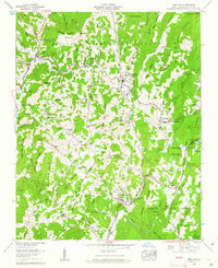
1960 Map of Newland
USGS Topo · Published 1962About this map
Newland serves as a central hub in this high-country survey, situated at the confluence of several mountain streams including Whiteoak Creek and the North Toe River. The 1960 landscape reveals a community structured around its mountain gaps and river valleys, with the Tennessee Valley Moore rail line navigating the complex terrain through Montezuma Gap. Notable for its concentration of family and community landmarks, the area is home to numerous rural congregations and resting places such as Sloop Chapel, Cuthbertson Ch, and Newland Cem. Higher elevations are defined by the Blue Ridge and the Pisgah National Forest, featuring landmarks like the Hawshaw Lookout Tower and the trout rearing station near Lake Kawana. This record captures the transition from traditional mountain settlements like Vale and Pyatte toward the development of recreation sites like Camp Linn-Haven.
Find a feature on this map
114 named features on this map. Tap any name to fly to it.
Don’t see what you’re looking for? This feature index may not catch every label — zoom into the map to look around manually.
Map Details
Editions of this 1960 Newland Map
4 editions found
Other maps of this area

1891 · Roan Mountain
USGS Topo · 1:125,000

1893 · Cranberry
USGS Topo · 1:125,000

1894 · Roan Mountain
USGS Topo · 1:125,000

1895 · Cranberry
USGS Topo · 1:125,000

1899 · Cranberry
USGS Topo · 1:125,000

1900 · Mount Mitchell
USGS Topo · 1:125,000

1902 · Cranberry
USGS Topo · 1:125,000

1902 · Mount Mitchell
USGS Topo · 1:125,000

1904 · Roan Mountain
USGS Topo · 1:125,000

1905 · Morganton
USGS Topo · 1:125,000