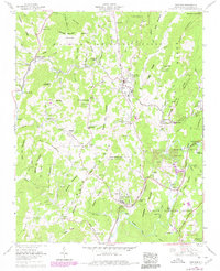
1960 Map of Newland
USGS Topo · Published 1979About this map
Newland serves as the focal point for this survey, situated at the high-elevation divide between the North Toe River and the Linville River. The landscape is dominated by the dense reaches of the Pisgah National Forest, where steep ridges like Blue Ridge Mountain and Big Elk Mountain define the settlement patterns. Human activity is concentrated along the river valleys and mountain gaps, marked by numerous small churches and family cemeteries such as Sloop Chapel and the Cuthbertson Cem. The region's dual character of remote wilderness and organized community is evident in the transition from an open pit mine near Little Elk Mountain to the recreational and institutional centers at Lake Kawana, Camp Linn-Haven, and the Trout rearing station. Many family-named landmarks like Stamey Town and Carpenter Bottom provide specific points of interest for genealogists tracing mountain ancestry.
Find a feature on this map
113 named features on this map. Tap any name to fly to it.
Don’t see what you’re looking for? This feature index may not catch every label — zoom into the map to look around manually.
Map Details
Editions of this 1960 Newland Map
4 editions found
Other maps of this area

1891 · Roan Mountain
USGS Topo · 1:125,000

1893 · Cranberry
USGS Topo · 1:125,000

1894 · Roan Mountain
USGS Topo · 1:125,000

1895 · Cranberry
USGS Topo · 1:125,000

1899 · Cranberry
USGS Topo · 1:125,000

1900 · Mount Mitchell
USGS Topo · 1:125,000

1902 · Cranberry
USGS Topo · 1:125,000

1902 · Mount Mitchell
USGS Topo · 1:125,000

1904 · Roan Mountain
USGS Topo · 1:125,000

1905 · Morganton
USGS Topo · 1:125,000