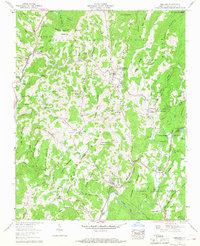
1960 Map of Newland
USGS Topo · Published 1968About this map
The Blue Ridge Parkway winds through the high elevations of Avery County in this 1960 survey, a landscape defined by the prominent Blue Ridge Mountains and the headwaters of the Linville River. The county seat of Newland serves as a central hub, surrounded by smaller mountain communities like Montezuma, Linville, and Pineola. Local industry and land use are evidenced by a trout rearing station near Anthony Creek and an open pit mine on the western slopes of Big Elk Mountain.
Find a feature on this map
110 named features on this map. Tap any name to fly to it.
Don’t see what you’re looking for? This feature index may not catch every label — zoom into the map to look around manually.
Map Details
Editions of this 1960 Newland Map
4 editions found
Other maps of this area

1891 · Roan Mountain
USGS Topo · 1:125,000

1893 · Cranberry
USGS Topo · 1:125,000

1894 · Roan Mountain
USGS Topo · 1:125,000

1895 · Cranberry
USGS Topo · 1:125,000

1899 · Cranberry
USGS Topo · 1:125,000

1900 · Mount Mitchell
USGS Topo · 1:125,000

1902 · Cranberry
USGS Topo · 1:125,000

1902 · Mount Mitchell
USGS Topo · 1:125,000

1904 · Roan Mountain
USGS Topo · 1:125,000

1905 · Morganton
USGS Topo · 1:125,000