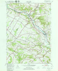
1943 Map of Newport
USGS Topo · Published 1980About this map
West Canada Creek dictates the layout of the valley as it flows through Newport and Poland, serving as a corridor for the New York Central West Canada Creek Line. This mid-century survey reveals a rural landscape defined by family-named crossroads and established community landmarks. To the southwest, the Irish Settlement stands near Tanner Hill, while numerous small schoolhouses like Poplar Tree Sch and Bullard Sch are scattered throughout the townships of Deerfield and Schuyler.
Find a feature on this map
52 named features on this map. Tap any name to fly to it.
Don’t see what you’re looking for? This feature index may not catch every label — zoom into the map to look around manually.
Map Details
Editions of this 1943 Newport Map
3 editions found
Other maps of this area

1897 · Remsen
USGS Topo · 1:62,500

1898 · Utica
USGS Topo · 1:62,500

1900 · Little Falls
USGS Topo · 1:62,500

1900 · Utica
USGS Topo · 1:62,500

1900 · Remsen
USGS Topo · 1:62,500

1900 · Wilmurt
USGS Topo · 1:62,500

1902 · Wilmurt
USGS Topo · 1:62,500

1903 · Little Falls
USGS Topo · 1:62,500

1939 · Little Falls
USGS Topo · 1:62,500

1943 · Newport
USGS Topo · 1:24,000