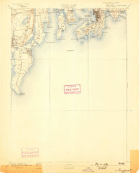
1894 Map of Newport
USGS Topo · Published 1898About this map
Coastal fortifications and maritime navigation markers dominate this late 19th-century survey of Narragansett Bay. The strategic importance of the harbor is visible through the prominent grounds of Fort Adams and Fort Walcott on Goat Island, while the safety of the Atlantic approaches is managed by Beaver Tail Light and the Brentons Reef Light Ship. Along the western shore, the developing resort culture of the Gilded Age is evident at Narragansett Pier, connected to the interior textile and agricultural hubs of Wakefield and Peacedale. The map illustrates a landscape of transit, from the South Ferry crossing to Conanicut Island to the numerous private landings like Watsons Pier that once dotted Boston Neck. Extensive coastal features including Eastons Beach and the jagged Point Judith Neck highlight the complex relationship between the Rhode Island seafaring economy and its shoreline.
Find a feature on this map
63 named features on this map. Tap any name to fly to it.
Don’t see what you’re looking for? This feature index may not catch every label — zoom into the map to look around manually.
Map Details
Editions of this 1894 Newport Map
3 editions found

Other maps of this area

1885 · Sakonnet
USGS Topo · 1:62,500

1888 · Fall River
USGS Topo · 1:62,500

1888 · Sakonnet
USGS Topo · 1:62,500

1889 · Charlestown
USGS Topo · 1:62,500

1889 · Newport
USGS Topo · 1:62,500

1889 · Block Island
USGS Topo · 1:62,500

1890 · Narragansett Bay
USGS Topo · 1:62,500

1890 · Kent
USGS Topo · 1:62,500

1892 · Narragansett Bay
USGS Topo · 1:62,500

1893 · Sakonnet
USGS Topo · 1:62,500