
1894 Map of Newport
USGS Topo · Published 1894About this map
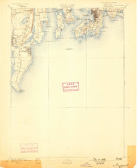
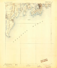
Newport and Middletown stand at the heart of this maritime survey, showcasing a landscape defined by coastal fortifications and established summer colonies in the late nineteenth century. The strategic military presence is anchored by Fort Adams and Fort Walcott, while the waters of Narragansett Bay are navigated via a network of signals including Beaver Tail Light, Lime Rock Light, and the offshore Brentons Reef Light Ship.
Find a feature on this map
63 named features on this map. Tap any name to fly to it.
Don’t see what you’re looking for? This feature index may not catch every label — zoom into the map to look around manually.
Map Details
Editions of this 1894 Newport Map
3 editions found
Other maps of this area

1885 · Sakonnet
USGS Topo · 1:62,500

1888 · Fall River
USGS Topo · 1:62,500

1888 · Sakonnet
USGS Topo · 1:62,500

1889 · Charlestown
USGS Topo · 1:62,500

1889 · Newport
USGS Topo · 1:62,500

1889 · Block Island
USGS Topo · 1:62,500

1890 · Narragansett Bay
USGS Topo · 1:62,500

1890 · Kent
USGS Topo · 1:62,500

1892 · Narragansett Bay
USGS Topo · 1:62,500

1893 · Sakonnet
USGS Topo · 1:62,500