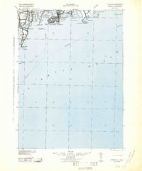
1942 Map of Newport
USGS Topo · Published 1942About this map
Coastal defenses and maritime hazards dominate this coastal view, produced by the War Department during the height of the second World War. A series of strategic fortifications, including Fort Adams, Fort Getty, and Fort Wetherill, stand guard over the entrance to Narragansett Bay and the waters of Newport. The map details the Naval Reservation infrastructure alongside civilian landmarks like Watsons Pier and the ferry routes connecting Jamestown to the mainland.
Find a feature on this map
62 named features on this map. Tap any name to fly to it.
Don’t see what you’re looking for? This feature index may not catch every label — zoom into the map to look around manually.
Map Details
Editions of this 1942 Newport Map
2 editions found
Other maps of this area

1885 · New Bedford
USGS Topo · 1:62,500

1885 · Sakonnet
USGS Topo · 1:62,500

1888 · New Bedford
USGS Topo · 1:62,500

1888 · Fall River
USGS Topo · 1:62,500

1888 · Sakonnet
USGS Topo · 1:62,500

1889 · Charlestown
USGS Topo · 1:62,500

1889 · Newport
USGS Topo · 1:62,500

1889 · Block Island
USGS Topo · 1:62,500

1890 · Narragansett Bay
USGS Topo · 1:62,500

1890 · Kent
USGS Topo · 1:62,500