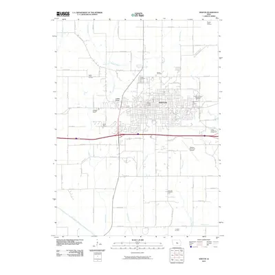
2010 Map of Newton
USGS Topo · Published 2010About this map
Newton serves as the central hub of this Jasper County landscape, showing a detailed urban grid transitioning into the rural Iowa countryside. The settlement of Lambs Grove sits just west of the main city center, nestled near the headwaters of Cherry Creek. This survey captures the region's complex cemetery network, documenting sites of genealogical importance such as the Moffitt Family Cemetery, Sacred Heart Cemetery, and Palo Alto Cemetery. The landscape is defined by its infrastructure and community spaces, from the high-speed curves of the Newton Speedway to the quiet grounds of the Newton Arboretum and Botanical Gardens. The southern reaches of the quadrangle are marked by the winding path of the South Skunk River and the small drainage of Reasnor Creek, illustrating the intersection of the town's industrial growth with the natural prairie waterways.
Find a feature on this map
50 named features on this map. Tap any name to fly to it.
Don’t see what you’re looking for? This feature index may not catch every label — zoom into the map to look around manually.
Map Details
Editions of this 2010 Newton Map
This is the sole edition of this map. No revisions or reprints were ever made.
Other maps of this area

1954 · Des Moines
USGS Topo · 1:250,000

1956 · Des Moines
USGS Topo · 1:250,000

1957 · Des Moines
USGS Topo · 1:250,000

1965 · Prairie City
USGS Topo · 1:24,000

1965 · Newton
USGS Topo · 1:24,000

1965 · Monroe
USGS Topo · 1:24,000

1965 · Colfax
USGS Topo · 1:24,000

1969 · Des Moines
USGS Topo · 1:250,000
1975 · Baxter
USGS Topo · 1:24,000

1975 · Baxter SE
USGS Topo · 1:24,000