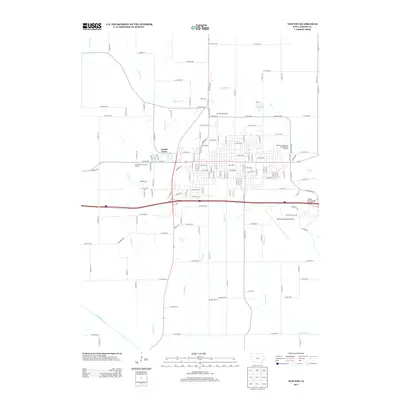
2013 Map of Newton
USGS Topo · Published 2013About this map
Lambs Grove sits as a distinct residential enclave on the western edge of the city, framed by the meandering path of Cherry Cr. The landscape transitions from a dense urban street grid to a hub of modern transportation and recreation, exemplified by the Newton Municipal Airport and the sprawling Newton Speedway to the north. These facilities highlight the area's role as a regional center for transit and sports at the beginning of the 21st century.
Find a feature on this map
75 named features on this map. Tap any name to fly to it.
Don’t see what you’re looking for? This feature index may not catch every label — zoom into the map to look around manually.
Map Details
Editions of this 2013 Newton Map
This is the sole edition of this map. No revisions or reprints were ever made.
Other maps of this area

1954 · Des Moines
USGS Topo · 1:250,000

1956 · Des Moines
USGS Topo · 1:250,000

1957 · Des Moines
USGS Topo · 1:250,000

1965 · Prairie City
USGS Topo · 1:24,000

1965 · Newton
USGS Topo · 1:24,000

1965 · Monroe
USGS Topo · 1:24,000

1965 · Colfax
USGS Topo · 1:24,000

1969 · Des Moines
USGS Topo · 1:250,000
1975 · Baxter
USGS Topo · 1:24,000

1975 · Baxter SE
USGS Topo · 1:24,000