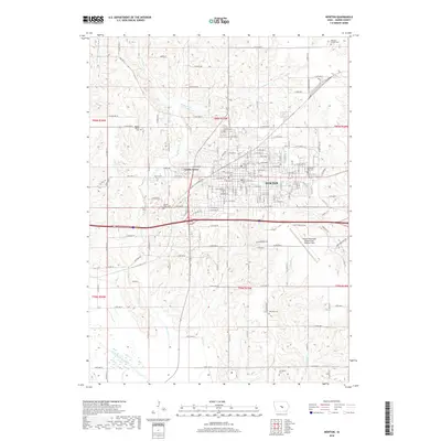
2018 Map of Newton
USGS Topo · Published 2018About this map
The city of Newton and the adjacent community of Lambs Grove form the urban core of this Jasper County landscape. A network of local roads and highways, including Monroe Dr and 1st Ave E, connects the residential and commercial blocks to the surrounding agricultural terrain. Along the southern edge of the quadrangle, the South Skunk River meanders through bottomlands, joined by several local tributaries such as Sewer Cr and Cherry Cr. This hydrographic system defines the drainage for the region, while the Newton Municipal Airport-Earl Johnson Field occupies a prominent position on the eastern side of the city. Genealogists will find several burial sites recorded across the townships, ranging from the Moffitt Family Cem in the northwest to the Livingston Cem in the south, documenting generations of local settlement.
Find a feature on this map
91 named features on this map. Tap any name to fly to it.
Don’t see what you’re looking for? This feature index may not catch every label — zoom into the map to look around manually.
Map Details
Editions of this 2018 Newton Map
This is the sole edition of this map. No revisions or reprints were ever made.
Other maps of this area

1954 · Des Moines
USGS Topo · 1:250,000

1956 · Des Moines
USGS Topo · 1:250,000

1957 · Des Moines
USGS Topo · 1:250,000

1965 · Prairie City
USGS Topo · 1:24,000

1965 · Newton
USGS Topo · 1:24,000

1965 · Monroe
USGS Topo · 1:24,000

1965 · Colfax
USGS Topo · 1:24,000

1969 · Des Moines
USGS Topo · 1:250,000
1975 · Baxter
USGS Topo · 1:24,000

1975 · Baxter SE
USGS Topo · 1:24,000