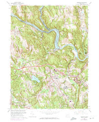
1963 Map of Newtown
USGS Topo · Published 1974About this map
The confluence of the Housatonic River and the Shepaug River defines this Connecticut landscape, which centers on the town of Newtown and the sprawling campus of the Fairfield State Hospital. Photorevised in the early 1970s, the map illustrates a region of varied institutional and residential development, from the Southbury Training Sch in the north to the unique enclave of Russian Village near the Pomperaug River. Transport and industry are marked by the Penn Central rail lines and several large Sand and Gravel Pits concentrated near Hawleyville. The expansion of Lake Lillinonah behind the Housatonic River reflects mid-century utility planning, while established neighborhoods like Sandy Hook and Pootatuck Park show the area's continued suburban growth. Local history is anchored by sites like the Newtown Village Cem and the prominent elevations of Taunton Hill and Sunset Hill.
Find a feature on this map
64 named features on this map. Tap any name to fly to it.
Don’t see what you’re looking for? This feature index may not catch every label — zoom into the map to look around manually.
Map Details
Editions of this 1963 Newtown Map
4 editions found
Other maps of this area

1889 · Derby
USGS Topo · 1:62,500

1891 · Derby
USGS Topo · 1:62,500

1892 · Danbury
USGS Topo · 1:62,500

1892 · New Milford
USGS Topo · 1:62,500

1893 · Waterbury
USGS Topo · 1:62,500

1893 · New Milford
USGS Topo · 1:62,500

1893 · Derby
USGS Topo · 1:62,500

1904 · New Milford
USGS Topo · 1:62,500

1904 · Waterbury
USGS Topo · 1:62,500

1904 · Litchfield
USGS Topo · 1:125,000