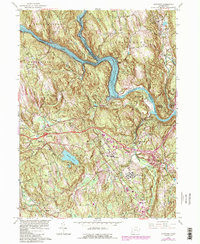
1963 Map of Newtown
USGS Topo · Published 1985About this map
The Housatonic River and the sprawling waters of Lake Lillinonah dominate this Fairfield County landscape during a period of significant mid-century transition. The arrival of Interstate 84 cuts across the center of the map, illustrating the modernization of Connecticut's transportation network as it bypassed established village centers like Newtown and Sandy Hook. The map documents a complex mix of land uses, from the institutional grounds of the Fairfield State Hospital and the secluded Russian Village to the industrial activity at several Sand and Gravel Pits near the Pootatuck River. Local genealogy and history are preserved in the locations of the Pierce Hollow Cem and Newtown Village Cem, while the Conrail line through Hawleyville shows the surviving rail infrastructure of the era.
Find a feature on this map
59 named features on this map. Tap any name to fly to it.
Don’t see what you’re looking for? This feature index may not catch every label — zoom into the map to look around manually.
Map Details
Editions of this 1963 Newtown Map
4 editions found
Other maps of this area

1889 · Derby
USGS Topo · 1:62,500

1891 · Derby
USGS Topo · 1:62,500

1892 · Danbury
USGS Topo · 1:62,500

1892 · New Milford
USGS Topo · 1:62,500

1893 · Waterbury
USGS Topo · 1:62,500

1893 · New Milford
USGS Topo · 1:62,500

1893 · Derby
USGS Topo · 1:62,500

1904 · New Milford
USGS Topo · 1:62,500

1904 · Waterbury
USGS Topo · 1:62,500

1904 · Litchfield
USGS Topo · 1:125,000