
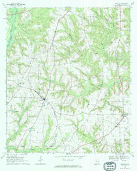
1969 Map of Newville
USGS Topo · Published 1972About this map
The Seaboard Coast Line railroad dictates the orientation of Newville in the late 1960s, cutting a diagonal path through the Henry County landscape. This agricultural corridor is anchored by the Rosenwall Sch and several community landmarks including Mt Sinai Cem and Rocky Mountain Cem. The terrain is defined by a dense network of tributaries like Sandy Creek and Noles Creek that feed the East Fork Choctawhatchee River in the northwest corner. To the east, smaller settlements like Tumbleton and Danzey appear alongside local aviation markers such as Herrings Airfield and a rural Landing Strip. The map illustrates a traditional Southern landscape where small-town centers and country churches, including Union Springs Ch and New Zion Ch, serve as the primary social hubs between the timbered branches and farm fields.
Find a feature on this map
37 named features on this map. Tap any name to fly to it.
Don’t see what you’re looking for? This feature index may not catch every label — zoom into the map to look around manually.
Map Details
Editions of this 1969 Newville Map
2 editions found
Other maps of this area

1953 · Dothan
USGS Topo · 1:250,000

1954 · Dothan
USGS Topo · 1:250,000

1955 · Dothan
USGS Topo · 1:250,000

1969 · Abbeville West
USGS Topo · 1:24,000
1969 · Midland City
USGS Topo · 1:24,000
1969 · Clopton
USGS Topo · 1:24,000

1969 · Headland
USGS Topo · 1:24,000

1969 · Abbeville East
USGS Topo · 1:24,000
1969 · Echo
USGS Topo · 1:24,000

1970 · Haleburg
USGS Topo · 1:24,000