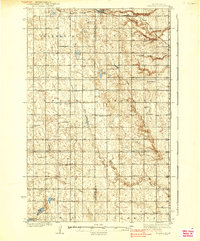
1939 Map of Niagara
USGS Topo · Published 1939About this map
The Adler Moraine bisects this prairie landscape along the border of Nelson and Grand Forks counties, defining a rugged terminal moraine that contrasts with the surrounding agricultural townships of Petersburg, Niagara, Logan, and Loretta. The small settlement of Niagara sits at the northern edge, served by the Great Northern railroad which cuts through the glacial till.
Find a feature on this map
31 named features on this map. Tap any name to fly to it.
Don’t see what you’re looking for? This feature index may not catch every label — zoom into the map to look around manually.
Map Details
Editions of this 1939 Niagara Map
2 editions found
Other maps of this area

1936 · Larimore
USGS Topo · 1:62,500

1939 · Niagara
USGS Topo · 1:62,500

1942 · McVille
USGS Topo · 1:62,500

1952 · Grand Forks
USGS Topo · 1:250,000

1952 · Thief River Falls
USGS Topo · 1:250,000

1952 · New Rockford
USGS Topo · 1:250,000

1953 · Devils Lake
USGS Topo · 1:250,000

1956 · New Rockford
USGS Topo · 1:250,000

1956 · Thief River Falls
USGS Topo · 1:250,000

1956 · Devils Lake
USGS Topo · 1:250,000