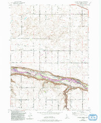
1979 Map of Niagara Springs
USGS Topo · Published 1992About this map
The Snake River carves a deep, dramatic path across this landscape, separating Gooding and Twin Falls counties. This 1979 survey, updated in the early 1990s, documents the vital water infrastructure of the Magic Valley, featuring complex systems like the Aqueduct and Siphon that support the local agricultural economy. Along the northern rim, the Niagara Springs Wildlife Management Area protects the unique hydrological features of the canyon, where Niagara Springs and Crystal Springs emerge from the basalt cliffs.
Find a feature on this map
19 named features on this map. Tap any name to fly to it.
Don’t see what you’re looking for? This feature index may not catch every label — zoom into the map to look around manually.
Map Details
Editions of this 1979 Niagara Springs Map
2 editions found
Other maps of this area

1949 · Thousand Springs
USGS Topo · 1:24,000

1949 · Tuttle
USGS Topo · 1:24,000

1950 · Niagara Springs
USGS Topo · 1:24,000

1950 · Filer
USGS Topo · 1:24,000

1950 · Jerome
USGS Topo · 1:24,000

1950 · Jerome
USGS Topo · 1:62,500

1951 · Thousand Springs
USGS Topo · 1:24,000

1951 · Tuttle
USGS Topo · 1:24,000

1951 · Clover
USGS Topo · 1:24,000

1954 · Thousand Springs
USGS Topo · 1:24,000