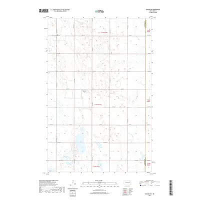
2017 Map of Niagara SW
USGS Topo · Published 2017About this map
Adler Union Cem serves as a lone local landmark in the northwest corner of this section of the Red River Valley, situated near the intersection of 121st Ave NE and 31st St NE. The landscape is defined by the prairie potholes and wetlands characteristic of the region, with Rugh Lake, Horseshoe Lake, and Hillesland Lake forming a chain of water bodies in the southern portion of the quadrangle. The Goose River and Goose Cr cut through the eastern and central sections, following the natural drainage patterns of the terrain. This area, spanning the border of Nelson and Grand Forks counties, remains largely agricultural, organized by a rigid grid of section roads and dotted with small clearings like Ricketyback Field.
Find a feature on this map
37 named features on this map. Tap any name to fly to it.
Don’t see what you’re looking for? This feature index may not catch every label — zoom into the map to look around manually.
Map Details
Editions of this 2017 Niagara SW Map
This is the sole edition of this map. No revisions or reprints were ever made.
Other maps of this area

1939 · Niagara
USGS Topo · 1:62,500

1942 · McVille
USGS Topo · 1:62,500

1952 · Grand Forks
USGS Topo · 1:250,000

1952 · New Rockford
USGS Topo · 1:250,000

1956 · New Rockford
USGS Topo · 1:250,000

1956 · Grand Forks
USGS Topo · 1:250,000

1963 · Niagara SW
USGS Topo · 1:24,000
1963 · McVille SE
USGS Topo · 1:24,000
1963 · Niagara
USGS Topo · 1:24,000

1963 · Logan Center
USGS Topo · 1:24,000